
SERVICES
#GLB Antenna Farm with the following Survey Grade and Commercial Antennas installed on two towers in "Ready to Use" condition.
Survey Grade Antennas
- Leica AR25
- Javad GrAnt G3T
- Javad GrAnt G5T
- SkyTraq Survey Grade
- ISRO IGS L5+S (under MoU with SAC, ISRO)
Compact, Commercial Antennas
- Tallysman Multi Constellation
- Taoglas Multi Constellation
- UBlox dual frequency, Multi Constellation
- GPS only low-cost Marine
- SkyTraq GPS+NavIC
#GNSS Reference Station with NTRIP Service
[Currently down due to Closure of University due to nCOVID19]
GNSS reference Station with Leica GR50 Multi-GNSS receiver (with NavIC) and AR25 Antenna has been established. We provide NTRIP Caster Service (24 x 7) onIP: http://14.139.211.21/index.lsp
Contact: abose@phys.buruniv.ac.in,
bugnsslab@gmail.com
#GNSS Support Services
GNSS Laboratory Burdwan (GLB) can provide support service to Industries, Research Organization for GNSS related test/ measurement/ collaborative research/ data services.#Training and Internship Facilities
Visit Opportunities Tab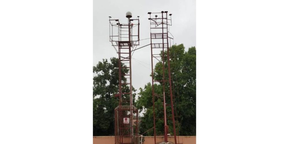
PRODUCTS
GLB-NavPVT 
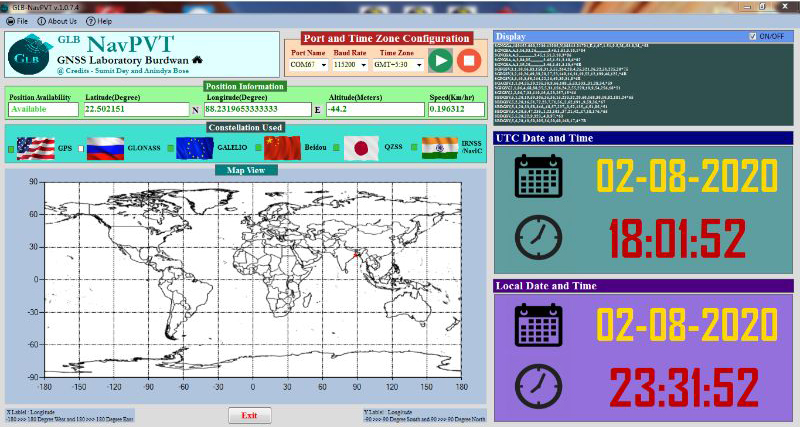
GLB-NavPVT is a Windows based GNSS Position, Velocity and GNSS Time display software. GLB-NavPVT can receive NMEA data from any GNSS Receiver/ OEM/ Module and displays in the GUI.
GLB-NavRX 
Copyright (Registration Number: SW-13744/2020) © 2020 GNSS Laboratory Burdwan, The University of Burdwan
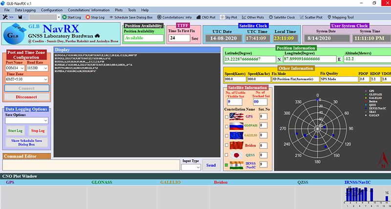
GLB-NavRX is a Windows Based GNSS Receiver/ Module independent software tool for Device control and GNSS data logging. Any GNSS receiver/ Module with NMEA output data may be connected to the USB port of the computer and can display Navigation, Satellite parameters (UI and online graphical display) with facility for constellation selection. NMEA data can be recorded in Continuous or Scheduled mode. Supports NMEA data files generated by Receiver/ Modules from most of the GNSS manufacturers (Javad, Leica, ISRO-IGS, UBlox, NTLabs, Skytraq, Telit, Allystar, Quecktel, uTraq, Elena ....)
UPCOMING PRODUCTS
GLB-GSoL 
(Copyright Pending)
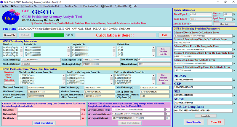
GLB-GSol is a Windows Based software tool for GNSS Positioning Solution Precision and Accuracy Parameters calculation from recorded NMEA data files. Text and Graphical Views. Supports NMEA data files generated by Receiver/ Modules from most of the GNSS manufacturers (Javad, Leica, ISRO-IGS, UBlox, NTLabs, Skytraq, Telit, Allystar, Quecktel, uTraq, Elena ....)
GLB-NavTracker 
(Copyright Pending)
GLB-NavTracker is a Windows Based software tool for analysis of Navigational satellite (Use status, elevation, azimuth) and satellite geometry (DOP) information from recorded NMEA data files. Text and Graphical Views for selected satellite(s) and constellation(s). Supports NMEA data files generated by Receiver/ Modules from most of the GNSS manufacturers (Javad, Leica, ISRO-IGS, UBlox, NTLabs, Skytraq, Telit, Allystar, Quecktel, uTraq, Elena ....)
GSLP
(Copyright Pending)
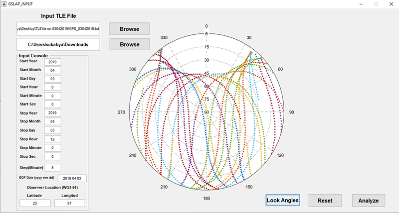
GNSS Satellite Look Angle Predictor (GSLP) is a Matlab based software package that predicts elevation and angle of GNSS satellite viewed from anywhere on earth surface. From the Two Line Element (TLE) file satellite positions in their orbit are calculated. GPS, GLONASS, Galileo and NavIC systems are considered in this version, and Beidou and QZSS would be included later. [Ref: https://doi.org/10.1080/02522667.2019.1703267]